The north-western boundary of Jubaland is a line drawn from the Lorian swamp, passing through the districts of Wajheir and Eil Wak, and terminating at Dolo, on the river Juba. Its south-eastern boundary is the Indian ocean. Its eastern boundary is the river Juba, whose eastern bank is within the Italian sphere of influence. The western boundary is an imaginary line from the Lorian swamp to the Bajun settlement of Kiunga on the coast. Off the coast is a series of coral reefs and small islands, partly inhabited, which makes the approach by vessels somewhat difficult.
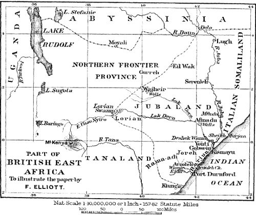
The available harbours are two in number, Kismayu and Port Durnford; the latter can only be entered by vessels of light draught. The mouth of the river Juba is blocked by a sand-bar, which can be crossed by vessels not requiring more than 6 feet of water. There is, in addition, the large creek of Arnoleh [Anooleh] (place of milk), which is navigable by dhows, and extends some 20 miles inland. Along the shore there is a line of sandhills stretching inland for about a mile. Their heights average not more than 200 feet, and they are clothed with bush and mimosa thorn.
Immediately behind the sandhills lies a flat country, thick with thorn and other bushes, but which possesses here and there open or park-like plains whereon cattle, camels and goats are pastured. As we proceed north-westward the belts of bush become denser and more difficult to penetrate, while in the more southern districts the open plains are larger and more numerous.
The general view of the country is uninteresting from lack of hills, and depressing from want of variety; yet it possesses great possibilities as a grazing country. Along the whole of the western bank of the river Juba lies a belt of what is called ” black-cotton ” soil, the fertility of which, under irrigation, may be compared to that of the Nile valley. It is already producing crops of cotton equal to the best Egyptian, and in the future might become a district of considerable commercial importance. The Juba, locally called the Webbe Ganana, rises in the mountains of southern Abyssinia. Its course is southward, but it winds in many directions. Its only tributary in Jubaland is the Daua. The local drainage is very small, and there are numerous swamps on either bank. The river is lowest from December to March, it then rises slowly until May. After this month the river again falls, and this fall is followed by its greatest rise, which occurs between August and November. The banks are well defined and clothed with vegetation and bush. The swamps lie beyond these banks. The river is navigable all the year round to Yonti. During the floods steamers can even reach Serenleh. The tsetse fly haunts the banks and swamps.