The Bajuni domain, at least since the 14/15thentury, is associated with the string of coral islands that runs from Kismayuu, 16 kms south of the mouth of the Juba, down to Kiwayuu Island in northern Kenya. just north of Pate Island, a distance of some 150 miles = 250 kms. There is also a narrow and discontinuous string of mainland settlements opposite the islands, starting with Kismayuu, and (FitzGerald’s (1898: 502) map shows Bajuni coastal settlements in the south ending at Dodori Creek, opposite Pate Island. Distances in kms: Kismayuu to Koyama 40, Koyama to Ngumi 10, Ngumi to Chula 20, Chula to Buri Kavo 25, Buri Kavo to Kiamboni 60, Kiamboni to Dodori Creek 100.
Bajunis and other coastal Swahili refer to the islands as just “the islands15”, other names being the Bajuni Islands, the 500 islands, and the Dundas group16. In recent times the Bajuni area stretched into northern Pate Island. The islands do not form a continuous line, there being a northern group from Kismayuu to Chandraa Island, just north of Buri Kavo, and a southern group from Kiungamwini in northern Kenya to Kiwayuu Island.
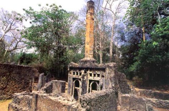
The biggest settlements were on the islands, mostly facing inland, with agricultural areas, some quite fertile and large, on the adjacent mainland, especially along the four rivers (Bajuni m(u)cho, pl. micho), some navigable, that run inland. The earliest reports suggest that in even earlier times these farming areas were run by slaves, controlled from the islands, but that was at a period when the Bajunis were more opulent and powerful. Today there are no settlements along the 35 miles stretch of mainland coast between Buri Kavo and Ras Kiamboni and on islands facing that coast. There are however ruins of earlier and smaller settlements, often walled, to protect them against marauders, human and animal.
The islands are small, Grottanelli (1955) giving these estimates of size for the main islands: Koyama 7.5 sq.kms, Chovae 6.5, Chula 5, Ngumi 4.5. Prins (1967: 28) says: “The islands are all low coral formations, withered by the sea and the breeze, and only covered by low bush, scrub, and a few palms and trees. Only the two or three bigger islands (Simambaya, Kiunga-mwini, Kiwayuu) are somewhat hillier, and, especially the first, somewhat more wooded. The whole range, together with the outcrops in between, forms a barrier reef protecting the mainland coast and the straits”.
(The Bajuni term for the Juba is Mucho wa Gobweni, ‘river of Gobwe’. Gobweni derives from Somali Goobweyn, a village 12 kms north of Kisimayu. The word consists of Goob = an open area, cleared of trees/bush + weyn = large, big. Probably the locality marks the mouth of the Juba.
In old travellers’ writings the river is called Ganane (especially in its upper course). The town of Lugh was called Lugh Ganane. Thanks to A. Vianello for this information. 15 Although the general word for ‘island’ is ki-dhiva (Sw. ki-siwa), a second, older word for ‘island’ appears in place names. So beside the well-known Kilwa in southern Tanzania, there is also, for example Kiwa-yuu in northern Kenya. Sacleux (1939: 421) says Kiwa/Kilwa refers to a small coral island. Kiwa/Kilwa consist of prefix ki– and stem –lwa, the latter going back to Proto-Bantu (Guthrie (1971: 126).
16 Medieval travelers mention the “Fire Islands”, off the East African coast, which might also be another earlier designation. 17 FitzGerald describes extensive Bajuni fields of millet and other plants on the mainland opposite Pate Island in the 1890’s, and said there were even more extensive adjacent areas, once cleared of forest, but then abandoned. He describes the slaves as Kamba, Taita, and others. He says Boni were employed to guard them and to keep the fields clear of birds and animals).
This makes it a relatively safe shipping lane for small local vessels, with larger cargo ships going outside the reef. Published accounts vary in their description of its width, at between 2 kms and 8 kms (5 miles). In recent times only Koyama, Chovae, and Chula were inhabited. When asked, Somali Bajunis will often mention seven islands, these three plus Kismayuu, Fuma, Ngumi, and Mdova.
Kismayuu Island was separate from the town of the same name until a connecting causeway was built in the 1960s. Examination of the oral traditions and the archaeological record suggests Ngumi was abandoned at the end of the 17th century. Mdova is a small island off the southern tip of Chula, the gap between them being easy to walk cross at low tide and fordable at high tide by leaping across rocks, so it might be Considered a separate island or not. In northern Kenya, northern Pate Island is home to Bajuni Communities, whose ancestors came from the north several centuries ago. Oral traditions, clan names, and archaeological ruins suggest earlier settlement on Chandraa, Simambaya, and Kiwayuu Islands.
Between most inhabited or once inhabited islands is a string of coral islets and outcrops, many with names given by fishermen. The islands are not fertile, being solid coral. Although the diet centered on fish, it did depend to some extent on the availability of crops from the mainland.
The 18th and 19th centuries were troubled times, when the farming areas and lines of communication with the islands were often interrupted by unfriendly Orma or, later, Somali, so this was a period of slow decline. Island populations were always small18, a major limiting factor being the supply of fresh water from the wells. The wells supplied fresh water from underground caverns, in which fresh and salt water were in balance. When populations grew too large, too much fresh water was drawn off, disturbing the underground mixture, resulting in water undrinkable by humans and only fit for washing or cattle19.
Today or at various points during the 20th century the water in the wells at Koyama, Ngumi, Chovae, and Chula is/was described as brackish and fresh water has to be brought from adjacent wells or even other islands. In 1898 FitzGerald states that many of the mainland wells between Buri Kavo and northern Kenya were brackish.
Various crops are recorded as being grown by Bajunis (Grottanelli (especially), Prins). Several kinds of millet (and sorghum), maize, several kinds of beans/peas, and sesame are mentioned in all sources as grown, and as contributing regularly to the diet. Pumpkin (squash?), sweet potatoes, andtomatoes get less mention, as do cotton, tobacco, and a very few coconut trees (for example on Chula and Koyama). It is less clear from the sources where and when these are grown: islands or mainland, all islands or just some, today or in the past? Many wild plants are used for medicinal, cosmetic, magical, and industrial purposes (see Grottanelli).
Fishing was all important to Bajuni society. When asked what work Bajunis do, there is always the same simple answer: “They (= men) fish”. They fish from the shore, inside the reef, and outside the reef in the open ocean. They use several different kinds of boats20. They use hooks and lines, weirs, 18 Mainland populations also: FitzGerald (1898) walked through a string of mainland Bajuni villages in northern Kenya and estimated the populations at 100 – 200 each
19 Islanders adapted to these sparse conditions. In Lamu in the 1970s a hydrologist told me that local people used five gallons of water a day per person for everything, whereas Europeans, with their wasteful ways (flush toilets, showers, baths, swimming pools) averaged 150 gallons a day. 20 Grottanelli (p190ff) describes three main types of Ba boats: mtumbwi, dau, mashua. In the past mtepe also a Ba type at least up to the 1920’s, but no more. Ngalawa and jahazi seen but not Bajuni types.
“All mitepe fly three flags on the masthead, white pennant is the flag of Ali of Shungwaya,.. below the white traps, plunge baskets, spears, and nets of different kinds. They catch dozens of types of fish, sharks, rays, shrimps, lobsters, and several varieties of turtle, the latter often by using sucker fish. Not only are fish
important in the diet, they are/were also dried and exported to Kismayuu, Lamu, and Mombasa. Beside fish, a limited trade in mangrove timber, cowries, and sewn goods (mats, hats) exists. Reports into the twentieth century talk of cloth being made on Koyama and Chula. Boats were built, and the Bajuni icon, the mtepe, as still built on Chovae into the 20th century.
[show_avatar email=11 user_link=last_post show_name=true avatar_size=67]