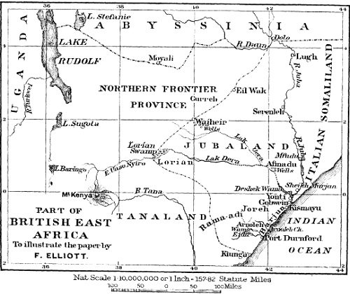
The Lorian swamp in the north-west corner of the country is in the rainy season for the most part a morass with a circumference of about 60 to 70 miles, but having moderately deep pools of water surrounded by reeds. In the dry season it is a mud flat with a permanent supply of water in its midst. This swamp is supplied from the slopes of the Aberdare mountains and Mount Kenya with water which enters it by the E. Uaso Nyiro river. There is a clearly defined river-bed, called the Lak Dera, connecting the Lorian swamp with the Wama lake. This river-bed is now dry, but the natives report that water has been known to flow down it as far as Afmadu (black mouth), which is a district about 30 miles from the river Juba.
The general direction of the above-mentioned Lak Dera (long stream) is east until it reaches the Afmadu district, where it is joined by the Lak Jera river-bed, and this has a stream of water during the season of heavy rains. After passing Afmadu the united river-bed turns almost due south until it reaches the Deshek Wama (Wama lake), a lake which formerly had permanent water extending 16 miles in length by about 2 miles in breadth. This lake was formerly fed by a stream proceeding from the river Juba at a point about 50 miles from its mouth, and it was drained by another stream entering the Juba 20 miles from its mouth, near the town of Yonti (noisy place).
The feeding stream has been lately blocked by an artificial bank, and the lake is now dry except in the rainy season.
Towards the south-west of Jubaland exists a plateau of slight elevation. From this in the rainy season a considerable amount of water flows into a series of swamps, drained by two creeks entering the sea by a common mouth at Port Durnford. These swamps are called by the general name of Wama Eidu.